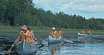
Vast expanses of deep blue lake shimmer right up to forested shores in Voyageurs National Park, a watery retreat favored by boaters, houseboaters and paddlers alike.
Meandering through 150 miles of Otter Tail County, the Otter Trail is a delightful drive. The trail guides travelers over rolling hills thick with maple, oak, and birch trees, past shimmering lakes and ponds sprinkled with white and yellow water lilies, and through fascinating towns alive with culture, history and fun things to see and do. This byway provides treats to delight all the senses!
Highway signs sporting a frisky otter clearly mark the circuitous route, and with the help of an Otter Tail County map available at any regional Minnesota Information Center, the journey makes a terrific day-trip. Travel through Fergus Falls, Battle Lake, Perham and Pelican Rapids in the most beautiful lake country Minnesota has to offer.
Details
Length:
150 miles (241 km)
Time:
Allow at least half a day to drive this byway, but you will need to spend several days to take it all in.
We offer a compact version of Go-Minnesota for mobile users, allowing you to access just the information you need on the road. Of course, you can still use the full version of Go-Minnesota on your mobile device just as you can on your desktop.