


Contact Info
- Phone 1:
- 218-388-2212
Basics
- Number of Sites:
- 7
Amenities
Basic Amenities
- Drinking Water
- Vault Toilets
Special Features
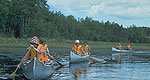
- Fishing
Details
Season
Open through Wed Oct 16 2013Location
Getting There:GPS Info. (Latitude, Longitude):
48.06778, -90.61472
48°4'4"N, 90°36'53"W
From Grand Marais, Minnesota, take Gunflint Trail (County Road 12) 36 miles north, turn left on County Road 92 and travel 2 miles on a narrow gravel road to Iron Lake Campground.
Basic Info
- Total Sites:
- 7
When portaging or paddling out of this lake and into another, visitors should find out if they will be entering the Boundary Waters Canoe Area Wilderness. Entry requires a permit (self-issued for day use) and visitors must follow wilderness regulations including group size.
**View recreation guides and maps of hiking trails and canoe routes in the national forest.
View recreation guides and maps of hiking trails and canoe routes in the national forest.

