


Basics
- Length:
- 154 miles (247 km)
- Time:
- 3 hours to drive the Byway, 1-2 days to enjoy stops along the way
- Fees:
- There are no fees along the Byway itself. Charges may apply at various points of interest.
Description
The North Shore of Minnesota has what no other place in the Midwest can offer -- an inland sea, a mountain backdrop, an unspoiled wilderness, and a unique feeling all its own. The North Shore is a place that you will want to come back to again and again.
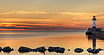
Drive the North Shore Scenic Drive from Duluth to the Canadian Border, and along the way see some of the most spectacular scenery in the country. Enjoy the natural treasures of eight state parks and the Superior National Forest. The beautiful trails of the parks and the 200-mile Superior Hiking Trail offer unlimited opportunities to experience firsthand this magnificent landscape. If you want to enjoy the lake itself, charter fishing, sailing, kayaking, and excursion boats are popular alternatives to swimming in these scenic northern waters.
The rich history of the North Shore is deeply rooted in its plentiful natural resources. On the northern end of the Byway, visit Grand Portage National Monument, which features a reconstructed North-West Company fur-trading post. Stop in Grand Marais, a quaint harbor town that is the entrance to the Gunflint Trail, a paved trail leading inland to the Boundary Water Canoe Area Wilderness. At the southern end of the Byway, watch giant ore boats pull up to the docks at Two Harbors. Also visit a much smaller boat, the 100 year-old tugboat, The Edna G., which is displayed here. Learn the story of this area in small museums in Two Harbors and Tofte, as well as interpretive programs at the state parks.
Tourism Resources
Helpful Links
Tourism Resources
Points of Interest
Points of Interest Along The Way
3M/Dwan Museum (MN)
Visit the birthplace of Minnesota, Mining & Manufacturing (3M), and the world's only museum dedicated to sandpaper.
Directions
Located in Two Harbors on Hwy 61, 1 mile from the start of the byway.
Beaver Bay (MN)
Beaver Bay was settled in 1856 by people of German and Swiss ethnicity. The town took part in many industries throughout the years and now offers a stop on the byway and some good fishing. Visitors can also explore historic places such as the Beaver Bay cemetery, a Chippewa Indian Burial Site. There are several shops, cafes, and restaurants in Beaver Bay as well.
Directions
Between Split Rock Lighthouse and Silver Bay on SR 61.
Butterwort Cliffs Scientific and Natural Area (MN)
Butterwort Cliffs consists of a narrow strip of wet rock shorenatural community on Lake Superior and the aspen-birch forest thatextends from the rock shore to the northern border of the SNA. Avariety of colorful lichens, ranging from orange to green, covermuch of the bedrock shoreline. The cool, moist climate near thelake provides habitat for a unique assemblage of rare arctic-alpineplants, including butterwort and Hudson Bay eyebright. Butterwort,for which this SNA is named, grows in fragile mats, its sticky,yellow-green leaves trapping insects as a nutritionalsupplement.
Directions
Butterwort Cliffs is located 8 miles west of Grand Marais on State Hwy 61 in Cascade River State Park.
Canada Border Crossing (MN)
This is one of the few places in the U.S. where you can go SOUTH into Canada.
Directions
Located 125 miles from the start of the byway.
Caribou River Wayside (MN)
This wayside has a view of the Caribou River and is the trailhead for the Superior Hiking Trail.
Directions
Located 46 miles from the start of the byway.
Cascade River State Park (MN)
Magnificent views of waterfalls and of Lake Superior are a pleasant surprise at this state park right on the byway.
Directions
The park is located about 10 miles southwest of Grand Marais on Hwy 61, at milepost 100.
Duluth (MN)
Duluth is the largest city on the byway. As a result, there areplenty of things to do there. At the tip of Lake Superior, Duluthhas been a transportation hub for many years. Now it remains amodest size and a gateway to the North Shore.
Directions
Near the byway off of I-35
Duluth Lakewalk (MN)
The Duluth Lakewalk stretches for 4.2 miles along Lake Superior.An entrance point to the lakewalk is just feet from the beginningof the North Shore Scenic Drive.
The Lakewalk features a boardwalk and an adjacent bituminoustrail for bikers, runners, and in-line skaters. Never more than afew feet from Lake Superior, the lakewalk offers excellent views ofthe harbor. In addition, interpretive signs dot the route withinformation on the history of the area.
Edna G. Tugboat (MN)
The Edna G. served Two Harbors from 1896 to 1981. It wasdesignated a National Historic Site in 1974, as the only steampowered tug still operating on the Great Lakes.
Now retired, the Edna G. features seasonal tours where visitorscan see her beautiful interior decor of wood paneling and brassfittings. Visitors will get a look at the captains quarters, theengine room, the crew's quarters, the galley, and the pilothouse.
Directions
South Avenue in Two Harbors
French River Wayside (MN)
This is a popular fishing area that also offers impressive viewsof the lake and the opportunity to watch the cascading FrenchRiver. The nearby French River Coldwater Fish Hatchery offersselected tours.
Directions
St. Louis County Highway 61

