


Basics
- Length:
- 54 miles (86 km)
- Time:
- 1.5 hours to drive the Byway, or four to six hours to enjoy the Byway
Description
Paul Bunyan is a giant among American tall tales, and the Paul Bunyan Scenic Byway captures the spirit of the famous lumberjack as it passes through tall forests, large lakes, and friendly northern communities. Soon roadside panels will tell the story of the Minnesota countryside in Paul's own words, and the attractions in the area allow visitors to experience all the fun of life on the frontier.
There's a tall tale behind some of the local architecture. When Paul was fishing for the 40-ft. walleye called Notorious Nate, he flung the fish so far that his bobber caught on the water tower scaffold of Pequot Lakes, where it remains to this day. Some say that Paul also built the Historic Fire Tower a mile east of Pequot Lakes, even though the Department of Natural Resources has it listed on the National Historic Lookout Register. Those who climb the hill and the tower find a Paul's-eye view of the surrounding forests, which makes a most excellent photo opportunity.
The forest remains much as it was in Paul's day, along with its many varieties of wildlife. The Uppgaard Wildlife Management Area contains fourteen different habitats that draw in non-game wildlife for visitors to enjoy. The Paul Bunyan State Trail connects several of the local townships along the path of the old railway, letting bikers, hikers, and cross-country skiers watch the local birds while enjoying the quiet of the forest.
The Whitefish Chain of Lakes is large enough to have come from several of Babe's hoof prints, and today, the recreational opportunities are equally gigantic. Like the scenery on its shores, the lake activities vary with the season, from summer waterskiing and swimming to winter snowmobiling, skiing, and spear fishing. Be sure to stop by the annual summer Duck Races at the Pine River Dam. Visitors can sponsor or cheer on one of a hundred racing decoy ducks, with prizes for the winner.
Through its expansive nature and its local storytellers, the Paul Bunyan Scenic Byway will capture visitors' imaginations.
Tourism Resources
Helpful Links
Tourism Resources
Points of Interest
Points of Interest Along The Way
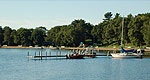
Cross Lake Dam Recreation Area (MN)
Operated by the US Army Corps of Engineers, the Cross Lake Dam and Recreation Center provides excellent recreation opportunities. Situated along the wooded shores of Cross Lake, the Recreation Area allows campers to experience nature within walking distance of local amenities. The lake also offers excellent water recreation.
Crosslake Historical Society Museum and Historic Log Village (MN)
The Crosslake Historic Log Village is made up of buildings taken from the surrounding area, each featuring information about its individual history. During the summer and fall seasons, volunteers from the Crosslake Historical Society staff the village and run occasional interactive history days, highlighting important period skills, including weaving and blacksmithing. The Historic Log Village makes an exellent stop for travelers preferring quiet and informative recreation.
Gateway Gazebo (MN)
The Gateway Gazebo provides an excellent introduction to the Paul Bunyan Scenic Byway near the town of Jenkins, MN. The covered gazebo is near several Byway attractions. In the A-Pine Restaurant, visitors can see a giant wooden cutout of Paul Bunyan, formerly used for the Paul Bunyan Cookie Company. The Gazebo is close to both miniature and par 3 golf courses, and during the summer, visitors can particiate in Scheer's Lumberjack Show to get a taste of the life of Paul Bunyan.
Historic Fire Tower (MN)
The Department of Natural Resources Fire Tower is listed on the Register of National Historic Lookouts and is one of the few that is still open to the public. The Historic Fire Tower is open to the public, accessible through a walking path followed by a steep climb. The tower provides an excellent view of the surrounding forest for sightseeing and photography, and it is also tied to the history of the region, playing a role in the forest fire of 1958. The area includes a parking area and picnic site at the bottom of the hill where the tower stands.
Paul Bunyan State Trail (MN)
Created through the Rails to Trails conversion program, the Paul Bunyan State Trail offers 110 miles of blacktop surface for biking, inline skating, snowmobiling, and cross-country skiing. The trail spans the lake filled forests of the Paul Bunyan Scenic Byway region, through great locations for bird watching and wildlife viewing.
The Paul Bunyan State Trail has trailheads in the Paul Bunyan Scenic Byway towns of Pequot Lakes, Jenkins, and Pine River. The trail also extends to other areas of Minnesota.
Pequot Lakes Information Center (MN)
The Pequot Lakes Information Center borrows from both legend and history in its unique architecture. Designed in the style of the town's original railroad depot, the information center hosts a staff well versed in the local lore. The center provides informative fliers and pamphlets for several Byway activities, such as boat rentals, fishing guides, and the location and history of area resorts.
The Information Center is also the home of several local community events. Legend has it that when Paul Bunyan went fishing for the forty-foot walleye Notorious Nate, he flung him from the lake right into the middle of town. Paul's bobber snagged on the water tower scaffold, and Nate hit with such force that he made a large hole. The settlers started cooking beans in this hole, and the Pequot Lakes Bean Hole Days were born.
Whether you're looking for information on Paul Bunyan, tubing hills, or the Antique Snowmobile Festival, you'll find the answers at the Pequot Lakes Information Center.
Pine River Dam Park (MN)
The Pine River Dam Recreation Park provides a tranquil place to fish from the pier, swim at the community pier, and camp under the pines. The dam marks the junction of Norway Brook and the west fork of the Pine River, and canoe enthousiasts can visit the nearby Pine River Information Center for more information about the official Pine River Canoe Route.
The Dam is also home to one of Pine River's most exciting events: the annual Duck Races. Each Friday from June to August, several decoy ducks participate in an intense competition. At the blast of a rifle, the ducks are dumped into the river at the dam, then paddle downstream to the finish line. Visitors can sponsor a lucky duck, with prizes for the winner.
Pine River Information Center (MN)
The Pine River Information Center, an official Minnesota state toursim center, provides authoritative information about local activities and culture. The capable Byway staff can both answer questions about recreation and entertain visitors with tall tales, as staff leader John Wetrosky demonstrates in this photo. Exhibits include local art and historic artifacts, a white buffalo head, and several pieces of Paul Bunyan memorabilia like the baby boots pictured here.
The center also provides information on local events and resources. Canoe enthousiasts can find information about the Pine River Canoe Route that passes through the town of Pine River, and other visitors can learn about the Pine River Duck Races held during the summer months.
Uppgaard Wildlife Management Area (MN)
The Uppgaard Wildlife Management Area, donated in 1987, contains 110 acres of landscaped wildlife habitat. Following Carroll Henderson's highly regarded reference book, Landscaping For Wildlife, the DNR manages the site to attract everything from butterflies to whitetail deer. As one of the few non-game wildlife areas, Uppgaard is perfect for nature watching. Its wide, well-packed woodland trails work well for hiking, biking, horseback riding, and cross country skiing.
The area features guided tours during the summer, departing every Wednesday at 9:30 am.
Veterans Hiking Trail at Island Lake Woods (MN)
The Veterans Trail winds through the Island Lake Woods, a section of restored forest near Hay Lake. In 1958, a forest fire on one dry summer day destroyed over 800 acres of old growth. Today, this peaceful forest hike reflects the successful reforestation effort, as it winds two miles through this Department of Natural Resources site.
This site includes a parking area and informative kiosk at the trailhead.

