


Basics
- Length:
- 54 miles (86 km)
Description
The Superior National Forest Scenic Byway from Aurora to Silver Bay runs through scenic Superior National Forest and Finland State Park, providing travelers with a relaxing drive through eastern Minnesota.
Many hiking trails are available along or close to the byway, offering visitors an opportunity to get out of the car and enjoy the natural beauty of Eastern Minnesota. Travelers will marvel at the 250-year-old White Pines along the White Pine Interpretive Trail. The 20-minute walking trail is only two miles north of the byway on Highway 2. Historical and observational information is available at various locations along the trail.
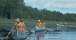
A little farther from the byway, but well worth the trip, Cadotte Lake Recreation Trail offers travelers a chance to picnic and enjoy the sights. Located in the Cadotte Lake Recreation Area near Fairbanks, the recreation area features fishing and boating opportunities. Fishing is a favorite pastime of locals in the area, and visitors from all around can partake of the tradition as they visit the byway. Travelers will want to dip their lines in the St. Louis River or Whiteface Reservoir, or join in the June Whitewater Walleye Classic in Hoyt Lakes.
The Skibo Vista Scenic Overlook near Hoyt Lakes shows off a beautiful panoramic view of the Laurentian Divide, especially during the fall. The divide captures the spirit of the area in breathtaking color, scenery, and wildlife. Visitors may even catch glimpses of migrating hawks.
Points of Interest
Points of Interest Along The Way
Long Year Drill Site (MN)
Established in 1890 by E.J. Longyear, the tradition and history of the historic diamond drill site has been preserved for viewing and learning.
Directions
From Hoyt Lakes, take county road 666 approximately 3.5 miles south.
Skibo Vista Scenic Overlook (MN)
A gorgeous view of the Laurentine Divide, the overlook features a panoramic view of what Minnesota can offer.
Directions
8 miles east of Hoyt Lakes
Superior National Forest (MN)
Experience the North Shore by fishing, hiking, camping, and just plain relaxing in the Superior National Forest.
Toimi Historic School (MN)
The Toimi Historic School was established in 1913 to serve the Finnish community of northeastern Minnesota. The school continued to be used until 1942.
Directions
Approximately 15 miles east of Hoyt Lakes on county road 110.

