


Contact Info
- Phone 1:
- 218-388-2212
Basics
- Number of Sites:
- 33
Amenities
Basic Amenities
- Drinking Water
Special Features
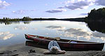
- Fishing
Additional Conveniences
- Boat Ramp
Details
Season
Open through Wed Oct 16 2013Location
Getting There:GPS Info. (Latitude, Longitude):
48.16028, -90.89361
48°9'37"N, 90°53'37"W
From Grand Marais, Minnesota, take Gunflint Trail (County Road 12) 57 miles north. Gunflint Trail ends at Trail's End Campground.
Basic Info
- Total Sites:
- 33
- Tent Sites:
- 15
Wildlife viewing is exceptional for bald eagles, osprey, loons and moose, and fishing is good for walleye, northern pike, smallmouth bass and lake trout.
View recreation guides and maps of hiking trails and canoe routes in the national forest.

